
***Please click on this link Map Locations of ALL Trails on this Site to view a map with the location of every trail “2oldguyswalking” has written a review on.***
Hazel Bird Nature Reserve (Baltimore, Ontario) Trail Review

UPDATE – December 16 2023 – Just returned from a walk here. It’s been awhile since we’ve been here and ALOT has been going on. The stewards of this site have introduced native grasses and (I think) planted more oak trees. It’s really being returned to it’s native state. We encountered a fellow shredding and removing stands of invasive Scotch pines which had been cut down. A very impressive effort indeed. I’ve always enjoyed this 4 km walk, but now it’s even better than ever !
My old walking buddy Ranger, and I, first walked this reserve years before the creation of 2oldguyswalking. It had no trail system, and was a difficult place to find access to. All this has changed over the last few decades, and I’ve been adding updates to reflect those changes. However, the updates were piling up, and the review was becoming confusing. So I’ve re-written it to incorporate those updates. This NCC (Nature Conservancy of Canada) land now has ample free parking on Beavermeadow Rd E. You can find it by heading North on Baltimore Rd (formerly highway # 45) from the 401 at Cobourg. Drive 5 kms to Cty Rd #15 (Harwood Rd) just past Baltimore. Drive another 9 kms to Beavermeadow Rd, turn right, and 2 kms along you’ll see the parking lot on the North (left) side. This link will open Google Maps at the parking lot : https://goo.gl/maps/joqopbNmnGhiWYUB7
There’s a kiosk with a trail map and some other info quite a ways off to the side of the trail. The trailhead isn’t marked well at this point so just follow the ATV tracks (ATVs are used to maintain the trail system, otherwise no motorized vehicles are allowed) heading North. You’ll walk alongside Beavermeadow Rd for about 300 meters following markers of blue rectangles on a white background. Then the trail makes a sharp right turn and continues another 200 meters to the beginning of the 4 km loop trail.

I would advise you to start the loop by taking it to the left. There’s a lovely lookout on this loop which involves a serious cardio workout if you don’t. You’re gonna have to climb a hill anyway, but it’s a lot less steep if you start from the left. The gradual climb you’ll take is through a canopied forest too, so you’ll be shaded. You’ll thank me as you walk down the hill from the lookout, particularly if you walk this one in the warmer months. UPDATE September 6 2022 – Just returned from a walk here and we saw there’s now a shortcut trail (in orange on the map) that will reduce a hill climb if you want.
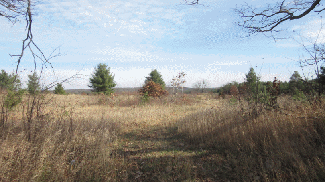
Speaking of shady forested sections … there’s only one, and it’s not much in length. You’ll need water and sun protection in warmer weather. This reserve is part of the Rice Lake Plains ecosystem and it’s mostly a prairie-like environment. So it’s very open to the sky, and it can get hot.

Taking the loop to the left will walk you through a section of low growing, shrubby landscape past the original access near the road. Then it’ll turn right, into a stretch of sandy dunes to the lookout. There’s a bench providing a pleasant rest stop to take in the view from. From here, you’ll take the steep walk down the sandy trail to the valley floor and not far beyond, into the forested section.
Through the forested section, you’ll gradually climb up a hill to the open sky plains again, and back to the beginning of the loop.
The Final Take
This trail is always a treat for me as we usually walk more forested trails, than plains. But I like the feeling of open air freedom this kind of trail provides. This Reserve is also one the heights of land in the Rice Lake area, so the views of the rolling hills to the North can be quite appealing. Being an unusual ecosystem (for this area) this trail also provides an opportunity to observe unusual plant life. You’ll experience, forest, plains, and sand dune ecosystems. The only thing it doesn’t have is water, but it doesn’t need it.
Other than parking, there are no facilities here, and no charges of any kind. There are two benches, one at the lookout, and another looking across the plains. I would describe the terrain as hilly, and potentially hot as there isn’t alot of shade.
Best of all, despite it’s proximity to roadways I’ve never noticed a sound out there, beyond the wind.
Have a nice walk,
Bushwhacker

Looks like a nice place to stroll around. 4k isn’t that long of a hike either.
LikeLike
We lived there when it was still a full 350 acres & there was no gravel pit. Our family were the last ones to live there some 20 years ago. Up the hill behind the house there is an old open well & further up was where the tv antenna was. We spent many days hiking around the property with our kids & lots of bbqs with family & friends. It was the best 5 years of our lives. Our kids still talk about the “chalet” today (it was originally called The Hillview Chalet). It makes my heart happy to see that so many others can enjoy for a few hours what we lived for 5 years. I have lots of pictures of how it used to be too
LikeLike
When I come home this summer I am going to make a point of going there and bringing back fond memories. Thank you for the walk.
LikeLike
Its always so rewarding to hear from family of a reviewed property. Glad I could help prompt fond memories. Thanks for sharing that with us.
Bushwhacker
LikeLike
We lived there with our 2 young kids 20 years ago & it was paradise. We’ve walked every inch of that property.
LikeLike
I know this place very well. Why? Because my family lived there for 5 years when it was still a complete 350 acre property. The bbq structure in the saw MANY family get togethers & the barn housed our horses. We have walked every inch of that property. It’s sad to see that the chalet itself was vandalized & ultimately destroyed but I was happy to see our bbq structure & barn still standing when we drove up today. Our kids caught the school bus at the end of the driveway which we walked every day (a mile each way). It’s been over 20 years, but we still miss it & cant wait to wander our place once again in the spring. I have LOTS of pictures of how it was before they cut up the property for that gravel pit, or whatever it is. If anyone would like to see the pics of the wonderful life our kids & we had, I would be happy to share.
Sue Geib (formerly from what was once called @the Hillview Chalet”
LikeLike
Hello Sue,
I’m glad we could spark a memory for you, and thanks for sharing them with us and our readers as well.
Bushwhacker
LikeLike
There is a link here to the Woodland Trails but I don’t see those listed on the map, is there another name?
LikeLike
Hello Stu,
Firstly, my apologies for the error you identified. Secondly, thank you for bringing it to my attention. You’re quite right. I had listed the wrong review under under the #18 and missed listing the Woodland Trails altogether. I think what happened was that I was in the process of reviewing the Woodland trails when I created the map and so I missed including it. The “Map Locations” page will be unavailable for a few minutes while I correct my error.
Thanks again Stu. Bye for now,
Bushwhacker
LikeLike
Glad to help, you are providing a great resource here. My Girlfriend and I have been to Beagle Club quite a bit this year as I know it well from my youth. We were looking for new trails to visit locally as Beagle Club turns over to the XC skiers when snow arrives.
We checked out Woodland and it didn’t leave the best first impression lol. The ruts were awful on the lookout trail as you mention, and a group of 5 young guys with a Dodge Ram pickup were trying to climb it, with dealer test drive licence plates no less. Just felt a bit too unsafe on this particular day. Hate to say weird vibes, but it was weird vibes haha. Most of the rest of the woods were nice, and the lookout view was great.
LikeLike
Yes … unfortunately, it’s gotten to the point where we won’t even try certain trails on the weekends, due to the idiots and brainless rednecks. I hope our efforts continue to be of use to you. Bye for now,
Bushwhacker
LikeLike